
Geoloqi IRC
2014-03-24
09:35 manny_ joined #geoloqi
10:05 patrickarlt joined #geoloqi
10:08 davy joined #geoloqi
10:17 patrickarlt joined #geoloqi
10:22 patricka_ joined #geoloqi
10:24 caseorganic joined #geoloqi
10:25 lyzidiamond joined #geoloqi
10:25 <lyzidiamond> caseorganic: i iz here
10:25 <caseorganic> lyzidiamond: excellent!
10:25 <caseorganic> here are the links: https://github.com/Esri/koop https://github.com/Esri/terraformer-arcgis-parser
10:26 <caseorganic> if you want to take a feature service and get available as a geoJSON?
10:26 <lyzidiamond> If you want to put together an email, I can send it out to all the 2014 fellows
10:27 <caseorganic> great
10:27 <caseorganic> i'll keep notes here and then put it all together
10:27 <caseorganic> feel free to ask tons of questions
10:29 <caseorganic> links to terraformer, leaflet, etc. github repo. developers.arcgis.com
10:32 <caseorganic> ArcGIS API for Javascript
10:39 patrickarlt joined #geoloqi
10:41 <lyzidiamond> caseorganic: Whenever I have JS API questions, I always go direct to Derek Swingley on Twitter. He is way into that, and he’s the one answering the forum and stackexchange posts.
10:41 <caseorganic> that's a great note for the email. thanks!
10:41 <lyzidiamond> np :)
10:42 <patrickarlt> caseorganic lyzidiamond what is this for?
10:43 <caseorganic> patrickarlt: trying to take down some notes from code for america arcgis training today
10:43 <caseorganic> patrickarlt: lyzidiamond: wants to make a quick email to send resource links to people at CFA using ArcGIS for the first time.
10:43 <patrickarlt> ah ok
10:44 <caseorganic> patrickarlt: yeah.
10:44 <lyzidiamond> ooh we should send out a link to this
10:45 <lyzidiamond> like, directly to this page he’s showing right now
10:47 lyzidiamond joined #geoloqi
10:55 <lyzidiamond> I think he may be being a bit jargony?
10:55 <caseorganic> lyzidiamond: it's the GIS degree stuff
10:55 <caseorganic> needing a GIS degree to understand a lot of this. most people come to this after 4 years of education
10:55 <lyzidiamond> right, exactly
10:56 <lyzidiamond> "feeding two masters" kind of thing
10:56 <patrickarlt> new topic for the developers site maybe?
10:56 <lyzidiamond> I'm trying to figure out what might be a good intro to this for folks who are not coming from GIS
10:56 <caseorganic> patrickarlt: yes
10:56 <lyzidiamond> patrickarlt: absolutely
10:56 <caseorganic> patrickarlt: as it's something that's making people glaze
10:56 <patrickarlt> http://mapschool.io/ is also a great resource
10:56 <lyzidiamond> +1
10:57 <caseorganic> lyzidiamond: patrickarlt: i need to dig up my old preso where i had a jargon file
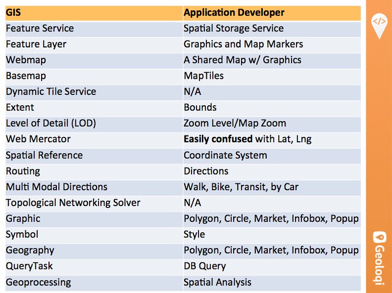
10:57 <caseorganic> LOD is Level of Detail - zoom level for instance
10:57 <patrickarlt> GIS people also like to use scale which is also zoom level
10:57 <lyzidiamond> So a fun thing to do is take all the jargon you use regularly and try to test people from different demographics
10:57 <lyzidiamond> "what does this mean to you" etc
10:58 <lyzidiamond> we try to keep an eye on that at CfA, cos we're bridging the gap between tech and government
10:58 <lyzidiamond> similarly, esri's new model is trying to bridge geography/GIS and developers
10:58 <lyzidiamond> (correct me if I'm wrong)
10:59 <patrickarlt> thats pretty much what i veiw my job as. that and growing usage of the arcgis platform
11:02 <caseorganic> What are best practices for Esri layers?
11:02 <caseorganic> patrickarlt: absolutely
11:02 <patrickarlt> Esri layers???
11:03 <lyzidiamond> I'm not sure if the folks in this room know what an "attribute table" is, necessarily, when using that terminology
11:03 <patrickarlt> ghhhhhh
11:04 <patrickarlt> pretty sure thats the database table that holds all the attributes associated with geometries
11:04 <lyzidiamond> oh I come from GIS, I know what it is
11:04 <lyzidiamond> I'm saying, the folks in the room
11:04 <patrickarlt> but most people in the room dont :)
11:05 <lyzidiamond> yes
11:05 <lyzidiamond> exactly
11:05 <caseorganic> patrickarlt: barely anyone in the room. 2 people said they'd even seen arcgis online
11:05 <caseorganic> 21 people
11:05 <caseorganic> the issue is that almost every city in the US uses arcgis for org, and they keep running into it
11:06 <patrickarlt> most people use ArcGIS Server + Desktop
11:06 <caseorganic> lyzidiamond: how did you learn gis?
11:06 <lyzidiamond> it's hard for me to assess what assumptions are being made because i've seen this before
11:06 <lyzidiamond> caseorganic: I have a GIS degree from UO
11:06 <patrickarlt> AGO is more of an add on to those things not its own product
11:06 <lyzidiamond> I'm wondering if an ecosystem explanation might be useful? we can also just ask the fellows
11:07 <caseorganic> patrickarlt: right AGO is a kind of front face to desktop, which is the real powertool
11:07 <caseorganic> patrickarlt: and following that analogy, which is the dev site?
11:07 <caseorganic> lyzidiamond: what would that look like? the ecosystem? want to draw a diagram? i can make it into an omnigraffle file
11:07 <patrickarlt> developers.arcgis.com is the docs...
11:08 <caseorganic> patrickarlt: great
11:08 <patrickarlt> most people just use it for docs all of our top pages are documentation pages. I expect that as we build more tools more people will use them though
11:11 <caseorganic> patrickarlt: lyzidiamond: http://farm3.staticflickr.com/2890/13385722283_e2d59515ec_c.jpg this is old, but is this reasonable accurate?
11:12 <caseorganic> GeoJSON and Feature Services - a city government sends you endpoints, and there's no way to do anything with it because we're not desktop users.
11:12 <caseorganic> terraformer.io is your friend for this - andy gup
11:12 <patrickarlt> lyzidiamond: would a command line tool to suck down a feature service as a GeoJSON Feature collection be a helpful thing?
11:12 <caseorganic> I think for an introduction to GIS for non geography-degree people we need a terminology
11:13 <patrickarlt> caseorganic: mapschool.io for the developers site
11:14 <caseorganic> "why would it be useful to convert geometry into esrijson?" A: because you cannot use geojson with arcgis. the only json that arcgis understands is esrijson. so you take your geojson and convert it to esrijson using terraformer.
11:14 <lyzidiamond> is that changing?
11:14 <lyzidiamond> :D yay sam
11:14 <caseorganic> "do you guys have plans to support geojson"
11:15 <patrickarlt> i think the answer is still "no" thats why the DC guys made koop
11:15 <lyzidiamond> ideas.esri.com <- Amber says "DO NOT USE IDEAS.ESRI.COM"
11:26 <caseorganic> "our city has a platform - kansas city has a parcel viewer. here is the map, but we can't find the data from the map to see what's going on and building with the data. finding the right URL. most of the city employees have the portal as their intervace"
11:27 <caseorganic> just the use case of having someone get a set of lat, long points from a city is very difficult.
11:27 <caseorganic> it took us 3 hours just to figure out how to query.
11:27 <patrickarlt> all problems we need to start solving
11:28 <caseorganic> great.
11:28 <patrickarlt> https://github.com/Esri/esri-leaflet#service-urls
11:28 <patrickarlt> should not be blank
11:28 <patrickarlt> clearer spots to show urls for things, better docs, more examples, api console
11:29 <lyzidiamond> I love how open y'all are to making these things easier for us
11:29 <caseorganic> as open data becomes more of a think, the use case for that to become more accessible
11:29 <caseorganic> trying to get people to solve the problem right now. i think we need a blog post for the most basic use case.
11:30 <caseorganic> as in, i told andy gup to try to solve one of the problems in real time on someone's laptop
11:31 <caseorganic> andy gup is going to write a blog post about this.
11:33 <caseorganic> he will write a blog post in exchange for a live link to the open data portal
11:33 <lyzidiamond> ^ Andrew Hyder, CfA tech team
11:33 <caseorganic> lyzidiamond++
11:33 <Loqi> lyzidiamond has 3 karma
11:34 <caseorganic> every city wants to make a open data portal
11:34 <lyzidiamond> ^ Mike Migurski
11:34 <patrickarlt> The open data portal is sweet. im pretty excited for it
11:37 <caseorganic> how do we add stuff to make it easier, and how do we also take stuff away that gets in the way?
11:37 <lyzidiamond> that is mike migurski
11:37 <lyzidiamond> CTO of Code for America
11:38 <caseorganic> "bake it into the actual update cycle the city has for their data." - mike migurski
11:38 <caseorganic> lyzidiamond: thank you!
11:39 <patrickarlt> caseorganic: was that make it easier comment for me?
11:40 <caseorganic> you need to know the schema esri uses
11:40 <caseorganic> patrickarlt: no - it was what mike said
11:40 <patrickarlt> ah
11:40 <caseorganic> patrickarlt: you're already making it easier. i'm just taking notes
11:40 <caseorganic> "it should be easier for middle school students to make this"
11:41 <caseorganic> "i should not have to know web mercator"
11:44 <caseorganic> "we're not your customers - we want to use the thing that your customers use"
11:47 <davy> I think it's fascinating that all three of your names are the same length. Makes for an interesting view of the sidebar. Just a giant block of yellow. :)
11:47 <caseorganic> "if people are stuck deconstructing end points"
11:47 <caseorganic> andy gup : our team had talked about a rest endpoint builder
11:47 <caseorganic> andy guy: where there's a little dropdown and you can you change it
11:48 <caseorganic> andy: then you can just go to a website and it would show you how to build that query
11:48 <caseorganic> "part of what we're trying to do is allow people to be creative with the use of these tools".
11:50 <caseorganic> "part of what we're trying to do is allow a lot of people to code for america"
11:51 <patrickarlt> case CFA is a good target audience for the developers site lots of good devs who have no idea how our stuff works but need/want to use it. we just need to make it easy for them
11:52 <lyzidiamond> davy: I just giggled out loud
11:52 <davy> lyzidiamond: :)
11:53 lyzidiamond joined #geoloqi
11:55 <patrickarlt> caseorganic lyzidiamond davy you should tell the CFA people they can email me with their pain points so we can build solutions to work through them
12:08 <caseorganic> patrickarlt: will do, thanks! gathering email addresses now of those who spoke
12:14 caseorganic joined #geoloqi
12:15 lyzidiamond joined #geoloqi
12:16 <davy> about to start taking notes on round table with jack, amber & myles
12:17 <patrickarlt> yay i want to hear all about it!
12:17 <davy> omg did you know amber is a cyborg anthropologist?
12:18 <davy> myles is a geographer that works with startups
12:20 <davy> now all the fellows are introducing themselves, lots of interesting and varied backgrounds
12:22 <lyzidiamond> TIM O'REILLY IN THE HOUSE
12:23 <davy> 'what are your thoughts about open data at esri?'
12:24 <davy> code for america has urged cities to open their data, esri is a leader in the space, esri's lead can pave the way for open data
12:24 <davy> different data sets reflect different disciplines
12:25 <davy> talking about andrew turner's open data initiative
12:25 <davy> open data as a service within arcgis online
12:26 <davy> esri urges cities to open up their data
12:26 <davy> example: parcel records used to be closed, wanted to sell the data
12:27 <davy> now parcel data is open
12:27 <davy> if you put the data & maps out in the open, can terrorists use it for eeeevil? doesn't actually stop bad things
12:28 <davy> *closed data doesn't actually stop bad things from happening
12:28 <davy> open street map started in UK due to data being present
12:30 <davy> 'it is not the policy of esri to restrict data in any way'
12:31 <davy> after 9/11 there was lots of talk at federal and state levels about security
12:31 <davy> we can't allow security to be the restricting part of open data
12:32 <davy> privacy: the game is already over
12:33 <davy> public data should be public. social infrastructure should not have cost recovery built in
12:35 manny_ joined #geoloqi
12:39 <davy> 'what could esri do to help publish data that needs more fuzzy geographical information (crime stats, archeology sites, etc)'
12:39 <davy> internal dataset with precise info, public data with fuzzy data
12:39 <davy> spacial fuzziness tools are available within the esri toolset
12:40 <davy> 'are you going to support geojson'
12:40 <davy> 'i dunno, are we?' - jack
12:40 <davy> 'I think we should' - amber
12:40 <lyzidiamond> davy++
12:40 <Loqi> davy has 55 karma
12:41 <davy> in order to be highly performant when updating very large datasets, need a format that can handle it
12:41 <lyzidiamond> "highly-indexed, topologically supported datasets"
12:43 <davy> web space is converging on geojson, would be nice to be easily able to hook up esri infrastructure
12:43 <davy> someone just brought up topojson
12:45 <davy> 'innovating inside of esri is probably similar to innovating inside of government'
12:45 <ngoldman> topojson doesn't work well for interactive stuff from what i understand, i think leaflet converts it to geojson under the hood
12:46 <patrickarlt> its a great transport format but it needs to be parsed to display as SVGs
12:46 <ngoldman> right
12:46 <lyzidiamond> bureaucracy
12:46 <davy> bureaucracy is good, and bureaucracy is bad
12:47 <davy> in order for esri to stay relevant, have to break up the existing tech and stay up to pace with the new things
12:47 <lyzidiamond> stay focused on the mission vs staying current with technology - a trade off
12:48 <davy> code for america is going to stir things up in government, help them incrementally move to new things
12:49 <davy> 'best arguments don't win, show don't tell'
12:50 <ngoldman> was that an amberism?
12:50 <davy> of course :)
12:50 courtf joined #geoloqi
12:51 <davy> there's always a good reason why a system is the way that it is
12:51 <davy> find the underlying reason, then see how to improve it
12:52 <davy> on startups: 'don't try to be interesting, try to be interested' - jack
12:53 <davy> what does the next 5 years look like at esri?
12:54 <davy> continue solving discrete individual problems
12:55 <davy> mentioning cloud gis platform (arcgis online) as a valuable thing to growth
12:57 <davy> continuing to open source things, continue to reach out to developers
12:57 <davy> more focus on helping the person who doesn't have a GIS degree, but needs to solve a problem really quickly
12:59 <davy> server => web => mobile, programming paradigm shifts
13:06 <davy> code for america is solving real problems, encounters the real functional gaps within esri software
13:06 <davy> need to rely on them to find out what new things we need to build
13:10 <davy> 2 million people use arcgis server to do their work every day
13:10 dr2391 joined #geoloqi
13:12 <dr2391> manny_: any news on the adhoc push fix?
13:13 <davy> half a million people are using arcgis online, and there are 1.5 million shared datasets
13:14 <davy> dr2391: hey, you've wandered in to realtime notes for a talk jack dangermond and amber case are having at code for america
13:14 <davy> I'll go see if manny is around
13:15 <dr2391> ok thanks!
13:16 <manny_> dr2391: hi. asking right now, update soon
13:17 <davy> cities use esri tools to map infrastructure, are we seeing cities use gis to map other things? like climate change?
13:18 <davy> need to predict what is going to happen, monitor what is actually happening, responding to what is happening, damage assessment and damage recovery. a whole spectrum of applications needed for city response
13:21 lyzidiamond joined #geoloqi
13:22 <davy> aaaand we're done
13:25 lyzidiam_ joined #geoloqi
13:29 <manny_> dr2391: fix has been found but has not been tested/deployed to the site
13:29 <manny_> dr2391: we just need to test that it works
13:29 <manny_> dr2391: trying to get an ETA for you.
13:29 <dr2391> sounds good. do you have an eta?
13:30 <dr2391> alright thanks
13:35 lyzidiamond joined #geoloqi
13:37 lyzidiam_ joined #geoloqi
13:38 lyzidiam_ joined #geoloqi
13:42 lyzidiamond joined #geoloqi
13:50 manny__ joined #geoloqi
14:00 lyzidiamond joined #geoloqi
14:02 lyzidiam_ joined #geoloqi
14:11 lyzidiamond joined #geoloqi
14:13 manny___ joined #geoloqi
14:14 <dr2391> manny___: trigger/history seems to return results from old to new, is there any way to reverse that?
14:15 <manny___> dr2391: in terms of eta, Wednesday is the day we are shooting for
14:16 <manny_> dr2391: as for reversing the results, as of right now there isn't.
14:17 <dr2391> alright thanks manny
14:36 patrickarlt joined #geoloqi
14:39 lyzidiamond joined #geoloqi
15:04 davy joined #geoloqi
15:04 patricka_ joined #geoloqi
15:27 davy joined #geoloqi
15:28 davy joined #geoloqi
15:56 davy_ joined #geoloqi
16:00 patrickarlt joined #geoloqi
16:03 lyzidiam_ joined #geoloqi
16:10 caseorganic joined #geoloqi
17:21 manny_ joined #geoloqi
17:21 davy joined #geoloqi
17:30 caseorganic joined #geoloqi
17:32 lyzidiamond joined #geoloqi
17:34 patrickarlt joined #geoloqi
18:20 patrickarlt joined #geoloqi
18:39 patrickarlt joined #geoloqi
19:00 patrickarlt joined #geoloqi
19:14 manny_ joined #geoloqi
19:20 manny_ joined #geoloqi
20:21 patrickarlt joined #geoloqi
21:59 patrickarlt joined #geoloqi
22:12 lyzidiamond joined #geoloqi
23:59 manny_ joined #geoloqi